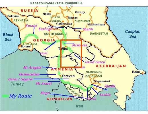
Davit Gareja marked on the map of the Caucasus regions. Its spelt David Gareji here. The spelling of Georgian place names varied a lot due to problems transliterating from the Georgian alphabet to the Latin one.
Davit Gareja is often billed as one of Georgia's star attractions but it is a bit of a pain to get to as it's pretty far from any decent size towns and there isn't any public transport going all the way there. The guide book just said we should join a tour as usual but as we were trying to keep our spending down we wanted to get there using public transport as much as possible. Luckily, two girls form our hostel had done the journey already and gave us the low-down on how to get there by marshrutka and taxi.
We grabbed some khatchapuri (cheesy bread) as usual for breakfast then took the metro to Isani station on the east side of Tbilisi. It was then just a 5 minute walk to the oddly named Navtlughe bus station where we managed to get a marshrutka going to Sagarejo, the last big town before Davit Gareja. Unfortunately, we stayed on the marshrutka a little bit too long and ended up in some rural area on the edge of town where the driver had gone to drop some locals off. We eventually realised our mistake when we were the only people left in the marshrutka. Panicking, we explained to the driver as best we cold where we were trying to get to. He then made it clear that he wanted to take us to Davit Gareja for 60 lari but we wanted to try to get it cheaper from in a taxi so he grudgingly dropped us off back in town.
We soon found a taxi that was willing to take us to Davit Gareja for 50 lari including 2 hours waiting time at the site. It was a long bumpy ride to get there through some very dry, arid but pretty looking countryside. We saw some very bright yellow/orange bird, pretty lakes and flowers and some interesting rock strata formations on the way. After driving for a long time we parked up finally at Davit Gareja. There was an old farm below where we were parked that used to be a collectivised farm in Soviet times and there were rocky slopes and caves above us. There were plenty of other visitors there too. We noticed that they were all wearing good solid hiking boots unlike us in our flip flops (as it was very hot), something that would come back to haunt us later.
Th rolling dry hills of the Azeri border. There was actually a lot more grass than we were expecting.
The former Soviet collectivised farm.
More fantastic scenery around David Gareja.
We started by exploring the courtyard of one of the monasteries though we weren't sure which one it was. We only had the vaguest idea of what there was to see at Davit Gareja though we knew there were several different monastery sites that would require some walking to get between. The guide book was light on facts as usual and there were no signs anywhere so we just stumbled about and hoped for the best. The first monastery was interesting and we saw a few small caves with carvings. Some areas were closed off as monks were still living there.
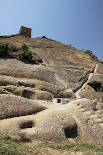
Caves and steps carved into the rocks to form the first monastery.
View of the monastery from above.
A religious painting in a cave within the monastery.
Looking up at the towers from within the monastery grounds.
Another shot of the monastery with the rolling hills in the background.
There were lots of cells and tiny chapels carved out of the cliffs.
We wanted to go to the main monastery mentioned in the guide book called "Udabno" meaning "desert" which is famed for its beautiful frescoes. However, we were told that it was a really steep and and difficult climb up dusty cliffs to get there that shouldn't be attempted in our sandals/flip flops. Unsurprisingly, given the semi-desert conditions, it was very very hot which was why we had come in sandals. The guide book had said that there would be "some walking between monasteries" but there was no mention of steep climbs that required hiking boots. Some people visiting the monastery complex that day even had hiking poles! We felt pretty stupid in our inappropriate footwear and were cursing our guide book furiously.
We ended up taking a different route towards some caves and a ridge that we were told was an "easy" climb and would have a good view out over Udabno. It turned into a bit of a disaster though as the climb wasn't at all easy as it was very steep and slippery from all the dust and bare rocks and we managed to get lost and ended up on an old disused path that got more and more treacherous. I started to wish I'd brought a machete with me to hack down all the prickly bushes that covered the path. It wasn't a fun experience! We did get a nice view back over the first monastery we visited though.
The whole of the first monastery site viewed from above on a higher hill.
The first monastery viewed from high up on the nightmare path we took by mistake.
We eventually found our way back onto the correct path but by then we were exhausted and it was still extremely steep, so much so that we were just slipping backwards out of our sandals so we gave up and walked back to the taxi, hot tired and defeated.
Me standing with my new best friend "Sticky" the stick that I'd needed to get up the ridiculously steep slopes.
The lesson here was - always bring the correct footwear and never rely solely on a guide book for your facts. We were both pretty disappointed that we hadn't seen Udabno but the semi-desert landscape was beautiful and the cave cells and churches that we did see were still worth the long trip.
Pretty semi-desert landscape around the monasteries.
An old crumbling watch tower that we spotted on the journey back to Tbilisi.
The arid hills quickly gave way to grassy plains as we left the Azeri border and headed back into central Georgia.
Overall, it had been an interesting trip but unnecessarily hard work and stressful. If you ever happen to go to Davit Gareja one day make sure you bring your hiking boots and get there early in the morning to beat the intense heat!


No comments:
Post a Comment